





China aggressively pursues its cartographic policies as part of its broader strategy to assert its territorial ambitions and expand its geopolitical influence.
Recently the Chinese Mission in Kathmandu sent a Note Verbale to Nepal’s Foreign Ministry, expressing concerns about Nepali textbooks and educational materials that depict Taiwan as an independent country. China has consistently opposed any representation of Taiwan as separate from its territory and has raised this issue with Nepal as well.
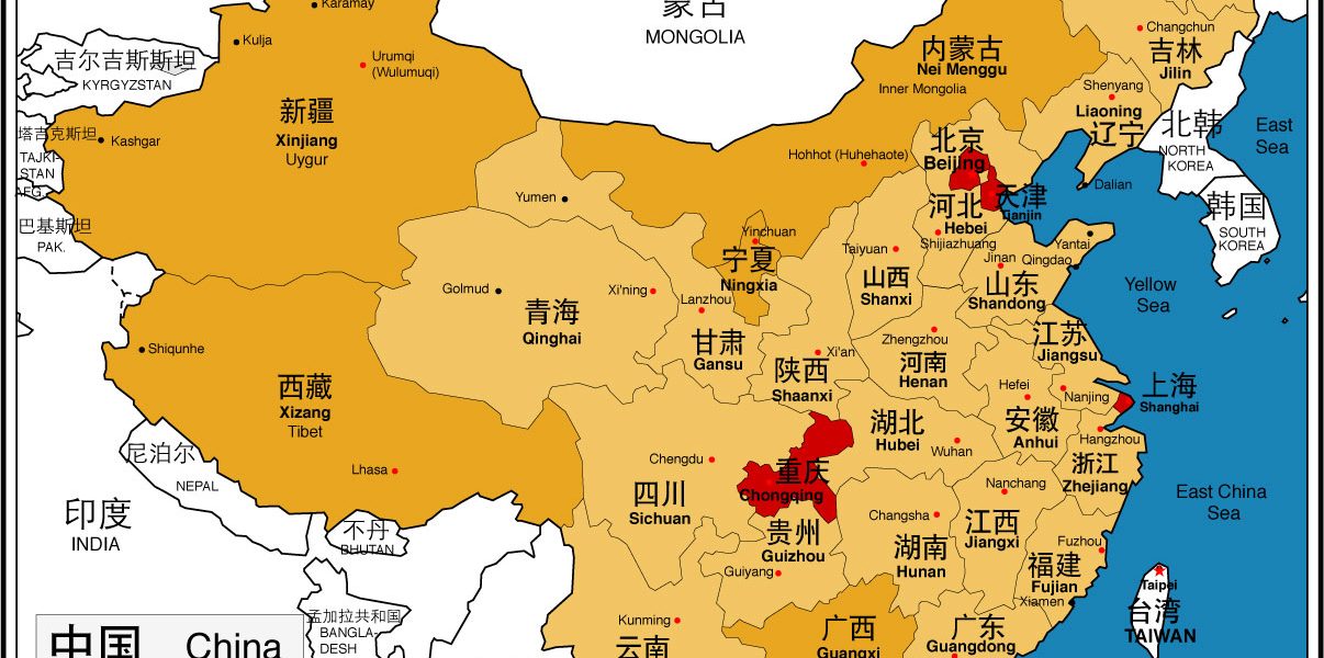
The specific objections raised by the Chinese Mission in Kathmandu on December 24, 2024 relate to the depiction of Taiwan as an independent country, the display of disputed areas in eastern and western sections of the Indo-China boundary as Indian territory and non-marking of the Ten-Dash Line (earlier referred to as the Nine-Dash Line) in the South China Sea.
It’s a delicate diplomatic situation, as Nepal seeks to balance its relationships with both China and Taiwan, at the same time maintaining its own sovereignty and the integrity of its own educational materials even as it is addressing Beijing’s pressures.
Prior to the issuance of the Note Verbale, on November 11, the Chinese Embassy in Nepal lodged a protest with Nepal’s Ministry of Foreign Affairs (MoFA) regarding a promotional poster of Taiwan’s National Parks displayed at the International Mountain Museum in Pokhara. China objected to the poster because it depicted Taiwan as an independent entity, which goes against China’s stance on Taiwan being part of its territory.
Nepal’s response to this protest has been to acknowledge the concerns raised by the Chinese Embassy but has not made any immediate changes to the display. This incident highlights the ongoing diplomatic challenges Nepal faces in balancing its relationships with both China and Taiwan.
China frequently releases new maps that assert its territorial claims, often coinciding with significant events or summits, suggesting a strategic timing to reassert its territorial claims. It is a recurring pattern that reflects China’s ongoing efforts to solidify its territorial ambitions. For example, the latest map was released ahead of the ASEAN and G20 summits in September 2023, drawing attention to China’s stance on these disputes.
In August 2023, China’s Ministry of Natural Resources released the updated version of the standard map of China. In the new map, China has made territorial claims over a small region in Russia-specifically Bolshoy Ussuriysky Island, on the Aksai Chin region in India’s Arunachal Pradesh referring to it as “South Tibet”, and a U-shaped ten-dash line” on China’s new map claiming Taiwan and around 90% of the South China Sea region whose territorial jurisdiction resides with the Philippines, Malaysia, and Vietnam.
The map contains altered names for multiple locations within these regions. Most of the territories mentioned above are either disputed or have been denounced as illegal Chinese intervention by various international tribunals, NGOs, and states. This newly released map outraged the international community for encroaching on the international (i.e., an area not under the sovereignty of any nation-state) and domestic territories of several neighboring countries. Encroachments have been observed where the territorial rights were disputed. India, Taiwan, Vietnam, the Philippines, and Malaysia released their official statements that the map is wrong or violates several of their domestic as well as international laws.
Neighboring countries have limited recourse available against this latest Chinese map. China does not recognize the jurisdiction of the ICJ and has refused to accept the authority of international bodies, as concerning territorial disputes.
Back in March 2019, Customs officials in China destroyed 30,000 “incorrect” world maps, showing Taiwan as a separate country and wrong depiction of the Sino-Indian border. The maps were meant for export to an unspecified country, state-run Global Times reported. Defending the act, Liu Wenzong, a professor from the Department of International Law of China Foreign Affairs University said, “What China did in the map market was absolutely legitimate and necessary, because sovereignty and territorial integrity are the most important things to a country. Both Taiwan and South Tibet are parts of China’s territory which are sacred and inviolable based on international law.”
Originally, China used the “Nine-Dash Line” to assert its claims over most of the South China Sea. However, the most recent version of China’s map released in 2023 has adjusted this to the “Ten-Dash Line.” The additional dash was added east of Taiwan, further emphasizing China’s claim over the island and the surrounding waters. Despite being rejected by the International Court of Justice in The Hague in 2016, it is still used today to justify the expansion of China’s naval presence in the region, its construction of artificial islands, and its intimidation of foreign fishermen. And any reference otherwise is not tolerated by China which has always taken a very assertive stance on map-related issues. In fact, even the American studios cater to China and its $4.6 billion film industry.
For the Chinese, the “Ten-Dash Line” signifies what the state considers its ‘legitimate’ claims to the South China Sea. For instance the makers of the movie Hollywood venture ‘Barbie’ had to clearly represent the Ten-Dash Line, demarcating Beijing’s contested ownership of the South China Sea.
Wall Street Journal reporter Erich Schwartzel in his book “Red Carpet: Hollywood, China, and the Global Battle for Cultural Supremacy” explains that movie makers have to be careful about “not including anything in your movie that risks angering the state.” This explains why in the movie ‘Doctor Strange’ the ethnicity of the Ancient One, a spiritual leader living in a mountainous monastery, has to be changed from Tibetan to Caucasian, and why in ‘Top Gun: Maverick’ the Taiwanese flag is removed from Pete Mitchell’s flight jacket.
Similar to the objections that China raised with Nepal, another recent incident involves the Chinese Embassy in Tanzania raising an objection to the Tanzania Revenue Authority (TRA) regarding the inclusion of Taiwan as an option in the nationality selection form on the TRA’s website. Here too, the Chinese Embassy sent a Note Verbale (NV) dated December 19, 2024, to the Tanzanian government, emphasizing that there is only one China and that Taiwan is an inalienable part of China’s territory. They requested the removal of Taiwan from the dropdown menu and to only include “China” as an option.
This move by the Chinese Embassy is part of China’s broader diplomatic efforts to assert its “One China” policy and discourage any recognition of Taiwan as a separate entity. The Tanzanian government has yet to publicly respond to this request, but it highlights not just China’s cartographic anxieties, but the complex nature of China’s interference in Tanzania and the potential implications for the country’s sovereignty.
China’s actions regarding maps and territorial claims can indeed be seen as interference in other nations’ sovereignty, making its own stance on non-interference complex and sometimes contradictory. While it advocates for non-interference in principle, its actions in various regions suggest otherwise. Because it considers maps as symbolic of sovereignty and national integrity, China responds strongly when other countries issue maps that conflict with its territorial claims, using it as an excuse to legitimize intervention, ignoring the other nation’s sovereignty.
This recent incidence of Chinese displeasure and subsequent interference in the internal affairs of countries like Nepal by objecting to maps that show Taiwan as independent, is a prime example of how China’s insistence on the non-interference principle has been increasingly inconsistent. China’s application of the non-interference principle has thus been made contingent. It is more inflexible at one end of a spectrum and more flexible at the other end, with China’s foreign policies shifting back and forth between them. It is crucial for the global community to address these aggressive cartographic practices and ensure that territorial integrity and sovereignty are respected.
Views: 116